
B-Line Proposal
Next Steps
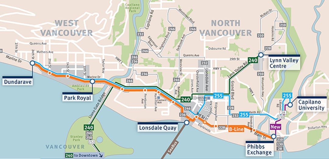
TransLink’s implementation of the RapidBus service to Park Royal is not expected to be completed until April 2020, after which Council has directed staff to examine options for extension into our town centre.
For information on the implementation of the RapidBus program, please visit:
Potential Expansion of the North Shore B-Line Past Park Royal
On March 11, 2019, Council resolved:
THEREFORE BE IT RESOLVED THAT staff be directed to:
1. Work with TransLink, the owners of Park Royal Shopping Centre, and the Squamish First Nation to identify possible alternative alignments / bus layby locations for a B-Line terminus option at Park Royal Shopping Centre (recognizing the District has no jurisdiction over Squamish Nation lands including the south side of Park Royal Shopping Centre, and lands under the jurisdiction of the Ministry of Transportation and Infrastructure);
2. Identify other potential options for a B-Line service extending beyond Park Royal Shopping Centre that would:
a. Avoid routing adjacent to schools;
b. Not require any restricted-access bus lane in the Ambleside or Dundarave business districts as agreed by TransLink;
c. Minimize the loss of on-street parking; and
d. Minimize impacts to residential neighbourhoods;
3. Convene a meeting(s) with Council, TransLink representatives, and Blue Bus staff to review detailed design plans for traffic improvement measures (excluding restricted access bus lanes) that could yield transit efficiency gains for local (Blue Bus) service and generally improve traffic flows along Marine Drive through Ambleside;
4. Identify order-of-magnitude costs and potential sources of funding for improvements/options identified in this resolution; and
5. Report back to Council with their findings on the above and the public consultation results, within 30 days, recognizing that this may only be an interim report at this time, to allow Council to decide next steps, and the appropriate subsequent public consultation.
Correspondence from TransLink regarding the potential expansion of the B-Line past Park Royal
Post your question about the proposed B-Line here and staff will post the answer publicly.
Personal information entered in this form is collected pursuant to section 26(c) of the Freedom of Information and Protection of Privacy Act for the purpose of augmenting and diversifying civic engagement (your username, question, and the District’s response to your question will be made public). If you have any questions about the collection and use of this information please contact Legislative Services, between 8 a.m. and 4:30 p.m., Monday to Friday excluding statutory holidays, at 604-921-3497 at Municipal Hall, 750 17th Street, West Vancouver BC V7V 3T3.
-
I don't understand why a combined figure of boarding and alightings is used to justify bus space. Is it possible to explain the demand it in terms of "leave load"? If you have this, could you supply it please? Thank you
Boardings and alighting figures were provided to demonstrate that transit is an important part of the West Vancouver transportation system. These figures provide insights into the type of activity we should expect within a community.Leave load provides important insights into how many passengers travel through a particular area, but it may not indicate where passengers start or end their trip.Slide 11 on TransLink’s presentation to West Vancouver Council on January 7th provides a measure of bus utilization on the corridor. It shows the leave load for eastbound customer and arrive load for westbound customers on an average weekday at 5 key intersections on Marine Drive in West Vancouver.Data Source: APC Passenger Count Data – Sept to Dec 2018 – Average daily Leave/Arrive Load (Mon – Friday)
Who's Listening?

Mayor and Council
The District is undertaking this engagement to determine whether the proposed B-Line should extend from Park Royal to Dundarave, and, if so, what changes might improve the proposal.
Document Library
-
 Report to Council: Proposed B-Line Community Engagement: Consultation Summary Report
-
Summary of all B-Line correspondence to April 15, 2019 (64.8 KB) (pdf)
-
Proposed B-Line Community Engagement: Consultation Summary Report (14.6 MB) (pdf)
-
Information Materials | Proposed B-Line Consultation | February 28, 2019
